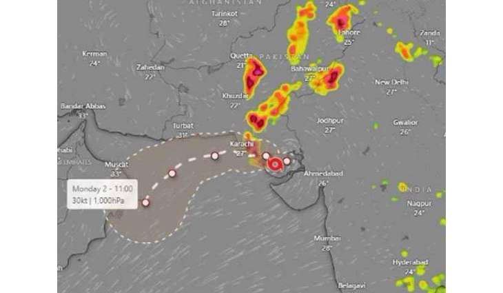
Pakistan Metrological Department says deep depression (DD, a very strong low-pressure area) has been slowly moving westward and southwestward over the past 12 hours from the Rann of Kutch in India, and is now approximately 270 kilometers southeast of Karachi
KARACHI: (UrduPoint/Pakistan Point News-August 29th, 2024) Meteorological Department has issued a tropical cyclone alert owing to deep depression over Rann of Kutch and potential sea storm in the northeastern Arabia sea.
The MET office said that deep depression (DD, a very strong low-pressure area) has been slowly moving westward and southwestward over the past 12 hours from the Rann of Kutch in India, and is now approximately 270 kilometers southeast of Karachi.
It is likely that this system will continue to move west and southwest, potentially reaching the northeastern Arabian Sea along the Sindh coast by late tonight or tomorrow morning.
The cyclonic storm is initially expected to move westward and southwestward, affecting Karachi Division, Tharparkar, Badin, Thatta, Sajawal, Hyderabad, Tando Muhammad Khan, Tando Allahyar, Matiari, Umerkot, Mirpurkhas, Sanghar, Jamshoro, and Dadu with thunderstorms and heavy rains until August 31.
The winds are likely to reach speeds of 50 to 60 kilometers per hour, causing the sea to remain rough and very rough. Fishermen have been advised not to venture into the sea until August 31.
The Meteorological Department is monitoring the cyclone warning center and the Karachi system. Authorities are requested to stay informed through the Meteorological Department's advisories.
Once the storm forms in the Arabian Sea, it will be named "Isna," which is the proposed name by Pakistan and means “elevated” or “higher”.
Given the favorable environmental conditions, sea surface temperatures, and upper-level divergence, there is a likelihood that this system will intensify into a tropical cyclone by Friday (tomorrow).