The National disaster Management Authority.says the system is forecasted to further weaken into a Depression state by Friday evening.
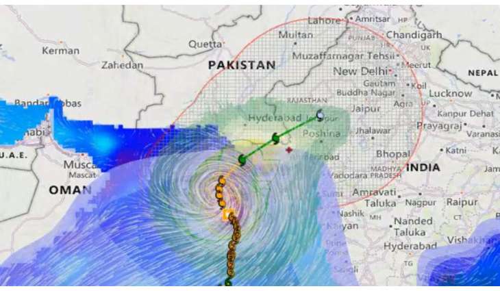
ISLAMABAD: (UrduPoint/Pakistan Point News-June 16th, 2023) The Severe Cyclonic Storm "BIPARJOY" has weakened into a Cyclonic Storm with sustained surface winds of 80-100 Kilometers per hour.
According to National disaster Management Authority, the system is forecasted to further weaken into a Depression state by Friday evening. However, major impact of landfall on the Indian side is observed. Requisite measures are being undertaken by all concerned to ensure preparedness and effective response.
The NDMA is continuously monitoring the system and will issue update accordingly. The Authority has issued the fresh advisory under which widespread rain and thunderstorms with some heavy or very heavy falls and squally winds 80-100 KM/h are expected in districts Sujawal, Badin, Tharparkar and Umerkot and heavy falls expected in Districts Thattha and Mirpukhas.
Dust and thunderstorm / rain, with few moderate falls & gusty winds 30-50 KM/h are likely in Districts Karachi, Hyderabad, Tando Muhammad Khan, Tando Allayar, Shaheed Benazirabad, Sanghar.
Squally winds in Districts Thatha, Sujawal, Badin, Tharparker and Umerkot may damage loose structures, kacha houses, under construction buildings, solar panels, trees and billboards.
Sea conditions along Sindh-Makran coast may get rough very rough with 2 meter tides.
Fishermen in Sindh and Balochistan will not be able venture into open sea until Saturday.
There are also high risk of storm surge of 6-8 feet along coastline, especially at Keti Bandar and surrounding areas, which may be exasperated by occurrence of hightide.