The India-Pakistani border area was hit on Tuesday by a 6.3 magnitude earthquake, the Indian Meteorological Department said
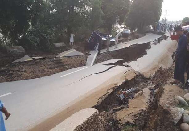
NEW DELHI (Pakistan Point News / Sputnik - 24th September, 2019) The India-Pakistani border area was hit on Tuesday by a 6.3 magnitude earthquake, the Indian Meteorological Department said."Earthquake of Magnitude: 6.3, Occurred on: 24-09-2019, 16:31:58 IST [11:01:58 GMT], Lat: 32.9 N & Long: 73.7 E, Depth: 40 Km [about 25 miles], Region: Pakistan - India (J & K ) Border region," the department wrote in its Twitter page.
According to the US geological Survey, the epicenter of the earthquake was located near the New Mirpur city in the Pakistani part of Kashmir.
The quake left at least five people dead and 50 more injured, the India Today newspaper reported.
India lies on the Indian tectonic plate, which has been moving to the north for some 100 million years, colliding with the Eurasian plate. This colossal geological process sometimes causes powerful earthquakes and resulted in formation of the Himalayas and other nearby mountain ranges that are the highest in the world.
On August 15, 1950, the continental collision caused one of the most powerful quakes in the recorded history: the so-called Assam earthquake with a 8.6 magnitude that left some 4,800 people killed. On October 8, 2005, the Pakistani part of Kashmir was hit by a 7.6 magnitude earthquake that killed over 86,000 people.