DUBAI, (Pakistan Point News - 29th Oct, 2019) Within one year of its launch, KhalifaSat captured 7,250 high-quality images and was able to complete 5,431 low Earth orbits, and communicated with the ground station at the Mohammed bin Rashid Space Centre, MBRSC, 906 times to send information and images, and receive updates. KhalifaSat sent 355 terabytes of data to the MBRSC’s ground station from across planet Earth.
KhalifaSat is the first satellite developed 100 percent in the UAE by a team of highly qualified Emirati engineers at the facilities of MBRSC. It was successfully launched into space from the Tanegashima Space Centre in Japan, aboard the H-IIA rocket, one year ago on 29th October, 2018.
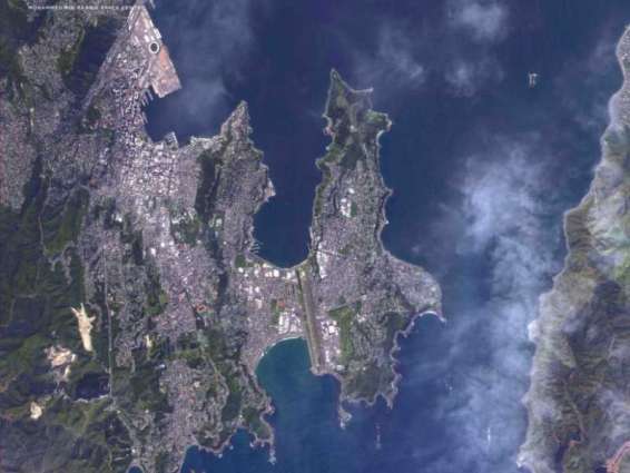
MBRSC highlighted that within one year of its launch, KhalifaSat captured images of Palm Jumeirah, Al Maktoum Stadium (Al Nasr Club), Kingdom Centre, Masjid al-Haram in Makkah, Al-Masjid al-Nabawi (the Prophet's Mosque), the Federal Territory Mosque in Kuala Lumpur, Malaysia, and the Baikonur Cosmodrome, where the first Emirati astronaut travelled to space.
It also captured images of major projects and achievements in the UAE and its construction work, including the Abu Dhabi International Airport and the surrounding area, in addition to the construction developments around The Louvre Abu Dhabi.
Yousuf Hamad Al Shaibani, Director-General of the MBRSC, said, "Today marks one year since the launch of KhalifaSat, the first satellite developed 100 percent in the UAE by a team of highly qualified Emirati engineers. After the outstanding performance, images and analysis it has provided, we celebrate the culmination of one of the UAE’s major achievements. This success proves that our youth can enjoy more achievements, reflecting the aspirations of our wise leadership."
Amer Al Ghafri, Director of Space Systems Development Department and KhalifaSat Project Manager, said, "One year after its launch, KhalifaSat is performing very well. It is still ahead of other satellites in the region, in monitoring and analysis. KhalifaSat will be able to capture more images in the next few years."
KhalifaSat’s mission is to provide detailed images for environmental monitoring, study areas, and urban planning. It also monitors environmental changes, ensures effective urban management, and aids in disaster relief efforts. KhalifaSat is capable of providing accurate information on the location, direction, and speed of ships. It also provides images monitoring development trends and changes on the planet, especially by government organisations. These images are then used in the design and production of detailed maps of the region.
KhalifaSat is the most technologically advanced UAE satellite, orbiting the ground at a height of 580-620 km, and the third satellite to be developed by the MBRSC after DubaiSat-1 and DubaiSat-2.